Catlin Seaview Survey Maps Coral Triangle

by | Oct 19, 2014 | Conservation, Corals, Photography, Science | 0 comments

catlin
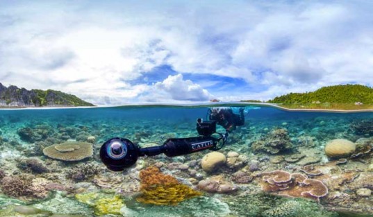
The Catlin Seaview Survey, the project which is out to capture and record the health of our World’s Reefs, is at it again. The goal of the project is to create a scientific baseline of the reefs, which can be used to monitor the changes in the World’s reefs over time.  The Catlin Seaview Survey have just finished capturing and mapping the Coral Triangle, a triangular area comprising of the Indian and Pacific Oceans of the Philippines, Indonesia and Malaysia. Over 3000 different species of fish reside in these waters, along with over 75 percent of all coral species, making it a diverse and flourishing marine ecosystem. The mission uses state of the art digital SLR cameras, which catch 360 degree images of the area.The photos will be available for viewing on the company’s database website, The Global Reef Record.MORE

  • Francis Yupangco

    Francis is a marine biologist with an MBA and over 20 years of professional aquarium experience. Francis is the former Aquatic Development Manager at Hagen USA., makers of Fluval brand aquarium products. He co-stars on Nat Geo WILD's reality TV series Fish Tank Kings where he is the resident "Fish Geek" and was Director of Marketing at Living Color Aquariums. He is an avid explorer having visited over 45 countries and lived in 7. At 17, he was among the youngest aquarists ever hired by the Vancouver Aquarium, where he worked for 7 years. His aquatic biology experience ranges from larval fish rearing to the design, construction and operational management of renowned public aquariums around the world. Francis is currently head of marketing at the world's largest vertically integrated fish farming company.

    View all posts

0 Comments

Submit a Comment

Your email address will not be published. Required fields are marked *